Estimated reading time: 8 minutes. Just enough time to look at a colonial map and realize that today’s traffic still follows yesterday’s ideas.
French colonial urban planning in Cambodia shaped much more than elegant boulevards and public buildings. It introduced a rational vision of the city where radial avenues, roundabouts, and carefully planned districts served administration, commerce, and public life. From Phnom Penh to Kampot, many of these urban choices continue to define how Cambodians move through their cities today.
Introduction
Walk through the center of Phnom Penh, Kampot, Battambang, or Kratie, and a pattern quickly appears. Broad avenues intersect at circles, public buildings occupy commanding locations, and markets seem perfectly positioned to organize the surrounding streets. These features are not accidental. They are the legacy of French colonial urban planning, a discipline that combined engineering, aesthetics, public health, and political ambition.
This article explores how French planners reshaped Cambodian cities from the late nineteenth century until independence in 1953. It explains why radial road systems became so common, why markets often stood at the center of urban layouts, and why landmarks such as Phsar Thom Thmey in Phnom Penh or the Durian Roundabout in Kampot continue to influence everyday life. Understanding these choices offers a new way to read Cambodian cities, where history remains visible beneath the modern traffic.
The French Vision of the Colonial City
French administrators did not simply build isolated monuments. They sought to create coherent cities that reflected order, efficiency, and modernity. Across the colonial empire, urban planning became a tool of governance as much as architecture.
Cambodia presented both opportunities and challenges. Many settlements had developed organically over centuries along rivers, canals, and royal compounds. Streets often followed local geography rather than geometric plans. The French introduced a more structured approach based on straight avenues, regular blocks, drainage systems, and carefully positioned civic buildings.
The objective was practical before being decorative. Better circulation facilitated trade, troop movements, sanitation, and administrative control. Beauty was certainly appreciated, but functionality usually came first.
Why Radial Roads?
Perhaps the most recognizable feature of French urban planning in Cambodia is the radial street pattern.
Instead of relying on a rigid grid alone, planners frequently organized important districts around a central landmark. Several major roads would converge toward this focal point, creating an efficient and visually impressive urban composition.
A Practical Solution
Radial roads served several practical purposes:
– They shortened travel distances between neighborhoods;
– They distributed traffic more evenly;
– They improved access to important public buildings and commercial centers;
– They created multiple evacuation and circulation routes during floods or emergencies.
Although automobiles were still relatively rare in Cambodia during the early colonial period, planners anticipated future growth. Wide avenues also accommodated bicycles, horse-drawn vehicles, pedestrians, and eventually motor traffic.
A Symbolic Statement
Urban planning also communicated power.
Standing at the center of a radial network naturally emphasized the importance of a building or monument. Government offices, markets, cathedrals, railway stations, and monuments became visual anchors that organized the surrounding city.
This approach reflected urban theories popular in France during the nineteenth century, particularly those inspired by Baron Haussmann’s transformation of Paris. While Cambodia was never rebuilt on the same scale, similar principles influenced colonial planners.
Phsar Thom Thmey: Phnom Penh’s Urban Compass
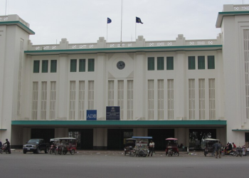
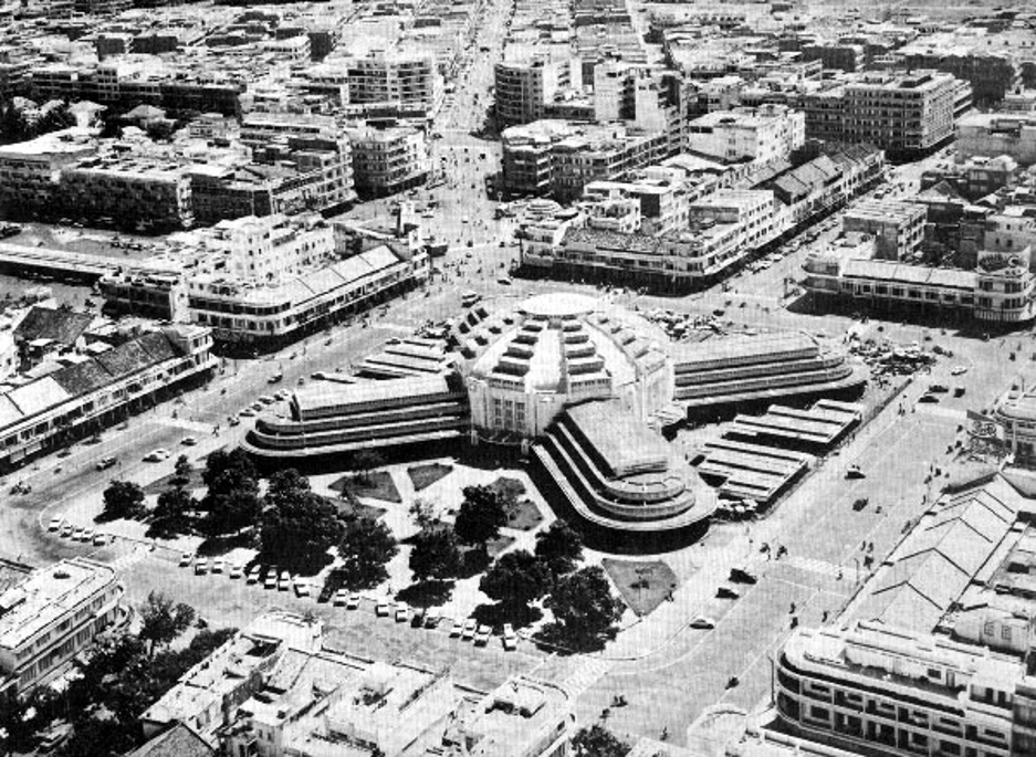
No example illustrates radial planning better than Phsar Thom Thmey market, better known internationally as the Central Market.
Completed in 1937, the remarkable Art Deco building was much more than a shopping destination. It became one of Phnom Penh’s principal urban hubs.
Several major avenues radiate outward from the market, allowing easy access from different parts of the city. Rather than hiding the market inside a dense commercial district, planners made it a true urban center.
The effect is immediately noticeable from above. Streets spread outward almost like the spokes of a wheel.
This arrangement achieved several objectives:
– It simplified access for merchants arriving from different neighborhoods;
– It reduced congestion by offering multiple approaches;
– It highlighted one of the city’s most prestigious public buildings.
Even today, thousands of residents navigate Phnom Penh almost instinctively by using the Central Market as a reference point.
Kampot and the Famous Durian Roundabout
If Phnom Penh demonstrates the grand scale of colonial planning, Kampot offers a smaller but equally revealing example.
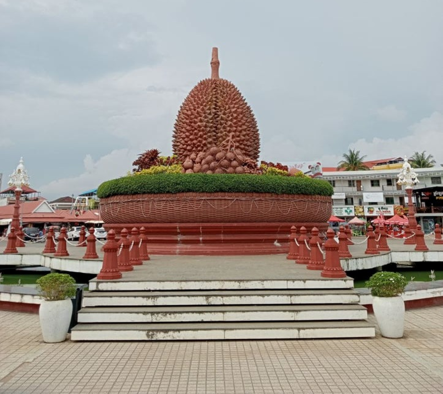
The city’s famous Durian Roundabout, although crowned today by its iconic fruit sculpture added much later, occupies a strategic urban position inherited from the colonial period.
Several important streets converge toward this central point before continuing toward residential neighborhoods, the riverside, the old commercial district, and the surrounding countryside.
The roundabout itself improves traffic circulation, but its location also reflects a classical planning principle. A recognizable landmark helps residents orient themselves while naturally distributing movement across the city. Visitors often photograph the giant durian without realizing they are standing on an urban design concept more than a century old.
Markets as the Heart of the City
More Than Places to Shop
French planners understood that markets generated constant movement.
Instead of placing them randomly, they frequently designed entire districts around them.
A central market attracted merchants, customers, public transportation, administrative services, and eventually banks, hotels, and restaurants.
The market became both an economic engine and an urban organizer.
This explains why several Cambodian cities still have colonial markets occupying remarkably strategic positions.
Public Space Around Commerce
Markets also created open public spaces.
Large squares and generous roads reduced fire risks, improved ventilation, and accommodated growing crowds during busy trading days.
In Cambodia’s tropical climate, better airflow was not merely comfortable. It contributed to public health by limiting stagnant air and facilitating drainage after heavy rains.
Roundabouts Were Never Just Decorative
Modern drivers sometimes joke that Cambodian roundabouts exist mainly to display statues.
Historically, they had far more serious functions.
Roundabouts slowed traffic naturally while maintaining continuous circulation.
They reduced complicated intersections.
They provided visual landmarks.
They offered prestigious settings for monuments or civic symbols.
The decorative sculptures that now characterize many Cambodian roundabouts often arrived decades after the road layout itself.
The urban design came first. The monuments followed.
Rivers, Floods, and Urban Logic
Urban planning in Cambodia could never ignore water.
French engineers quickly recognized that successful cities depended on efficient drainage as much as elegant architecture.
Road alignments often worked together with canals, retention ponds, and drainage networks.
In Phnom Penh especially, urban expansion required major hydraulic projects. Parts of the modern city were gradually created through the filling of lakes, marshes, and waterways, allowing new neighborhoods and road systems to emerge. This process began during the colonial period and has continued, in different forms, into the twenty-first century.
The relationship between roads and water explains why many avenues appear unusually broad. They frequently accommodated underground drainage infrastructure in addition to transportation.
Colonial Planning Beyond Phnom Penh
Although Phnom Penh received the greatest investment, similar planning ideas appeared elsewhere.
Battambang combined broad avenues with administrative quarters and commercial districts linked by logical street layouts.
Kampot developed around its river while integrating generous boulevards and civic buildings.
Kratie preserved elegant riverfront alignments that still define the city’s character.
Even smaller provincial towns often reveal traces of French planning through tree-lined avenues, public squares, and carefully positioned administrative buildings.
The scale varied, but the underlying philosophy remained remarkably consistent.
A Legacy That Still Shapes Daily Life
Many Cambodians probably navigate colonial urban planning without thinking about its origins.
The road chosen to reach the market.
The roundabout used as a meeting point.
The boulevard leading toward the river.
These everyday movements follow patterns established more than a century ago.
Of course, modern cities have expanded far beyond colonial boundaries. New districts, expressways, and suburbs have transformed Cambodia’s urban landscape.
Yet the colonial cores remain surprisingly resilient.
They continue to function because they were designed around practical principles that still make sense today: accessibility, visibility, circulation, and public space.
Urban historians often observe that the best city plans become almost invisible. People simply use them without questioning why they work.
Cambodia offers many examples of precisely this quiet success.
Conclusion
French colonial urban planning left Cambodia with far more than attractive architecture. It introduced an enduring urban logic where radial roads, markets, roundabouts, and broad avenues combined efficiency with civic identity. Whether standing beneath the dome of Phsar Thom Thmey or beside Kampot’s famous Durian Roundabout, visitors are not only admiring landmarks. They are experiencing a carefully planned vision of the city that continues to shape Cambodian life every day.
About the author
Pascal Médeville is a writer and digital publisher based in Cambodia. Through Wonders of Cambodia, he explores the country’s history, architecture, culture, and everyday heritage, helping readers discover the stories hidden behind familiar landscapes and remarkable places.